5

A 300-Year Typhoon Record in Taiwan and the Relationship with Solar Activity (also here) shows that about 30% of all typhoons in the western north pacific (WNP) affect Taiwan. (Author's home page)

I'm not sure how "affect" is defined there, but there are certainly a lot of them, and Taiwan depends on them. This spring there is a serious shortage of water in reservoirs due to an inadequate number of typhoons in the last year or two.

Question: Why do 30% of all typhoons in the western north pacific (WNP) affect Taiwan? What is it that seems to focus typhoons towards Taiwan?

Fig. 3. The ratio of the number of typhoons affecting Taiwan to the total number of typhoons over the WNP.

Fig. 3. The ratio of the number of typhoons affecting Taiwan to the total number of typhoons over the WNP. (a) The yearly values and the 11-year running means are shown as a bar and red line, respectively. (b) The 10-year accumulated ratio for (a). “std” refers to the standard deviations for the ratio.


An Inventory of Tropical Cyclone Tracks https://www.ncei.noaa.gov/news/inventory-tropical-cyclone-tracks

Source: An Inventory of Tropical Cyclone Tracks

uhoh
  • 7,076
  • 2
  • 30
  • 91
  • 2
    cyclone tracks in WNP are influenced by https://en.wikipedia.org/wiki/Tropical_upper_tropospheric_trough –  Jun 04 '21 at 01:56
  • 1
    Cyclone tracks are also influenced by upper level ridges. In your case take a look at climatological position of West Pacific Sub Tropical High - https://link.springer.com/article/10.1007/s00382-019-04705-4 –  Jun 04 '21 at 03:23
  • 1
    The West Pacific Sub Tropical High has basin wide scale. So I think that would influence cyclone tracks than the TUTT. TUTT will aid in cyclonef formation and intensification and maybe aid in tracking too but the ridge has higher importance in tracks –  Jun 04 '21 at 03:25
  • 1
    https://rmets.onlinelibrary.wiley.com/doi/abs/10.1002/qj.3407 and https://rmets.onlinelibrary.wiley.com/doi/full/10.1002/asl.893 –  Jun 04 '21 at 03:27
  • 1
    From this paper - https://www.mdpi.com/2073-4433/11/5/543 - "The location of Taiwan makes it vulnerable to the pathways of typhoons mainly determined by the position of the Pacific subtropical high" - question answered. Will it pass ? –  Jun 04 '21 at 03:39
  • @gansub your answers are generally excellent, and it looks like you're likely to nail it with all that! Everybody can votes on answers (SE's main feedback on answer quality) the only thing the OP holds is the "accept" button and one vote, plus (as in this case) the occasional bounty. I can't pre-accept an unwritten answer nor pre-award a bounty, and since the bounty just started there is always the chance of other answers in the next seven days plus one day grace period. These are just the realities of Stack Exchange. – uhoh Jun 04 '21 at 04:57
  • @gansub but in my experience a really good answer (which it looks like you've got) generally "passes". :-) – uhoh Jun 04 '21 at 05:02
  • @gansub 22 hours (plus 24 hours grace period) left on the bounty – uhoh Jun 10 '21 at 01:32
  • 1
    I will have it done before that. –  Jun 10 '21 at 04:40

1 Answers1

4

Cyclone tracks are influenced by the environmental wind. These can include subtropical ridges, mid latitude upper level troughs , other tropical cyclones (Fujiwara effect) and other transient highs and lows. Specifically in the Western North Pacific there are two synoptic scale phenomena that can influence cyclone tracks - Tropical Upper Tropospheric Trough and the western Pacific sub tropical high ridge - Subseasonal zonal variability of the western Pacific subtropical high in summer: climate impacts and underlying mechanisms.

While the tropical upper tropsopheric trough is known to influence cyclone tracks as shown in this paper A Conceptual Model for the Influence of TUTT Cells on Tropical Cyclone Motion in the Northwest Pacific Ocean we are going to focus on the influence of the West Pacific Sub Tropical High as that is directly related to OP's question.

A recent paper titled The Climatological Analysis of Typhoon Tracks, Steering Flow, and the Pacific Subtropical High in the Vicinity of Taiwan and the Western North Pacific details the impact of the subtropical west pacific ridge on the deep layer mean steering flow of tropical cyclones that make landfall on the Taiwan mainland .

The West Pacific Sub Tropical High is a ridge that exhibits structure from 850 hPa to 500 hPa.

enter image description here - 
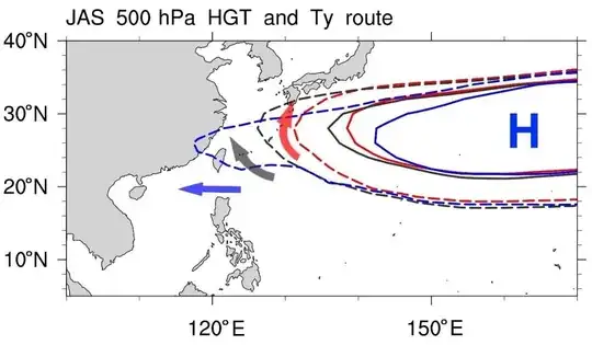
Image taken from this paper - The Climatological Analysis of Typhoon Tracks, Steering Flow, and the Pacific Subtropical High in the Vicinity of Taiwan and the Western North Pacific. The image is the July August September 500 hPa geopotential height climatological value over the western pacific.

The above displayed image taken from the linked paper summarizes the flow of TCs in the vicinity of Taiwan. Assuming the subtropical ridge western extent is located between Taiwan and Kyushu(shown in blue dotted line) the mean steering flow is such that it steers tropical cyclones towawrds the Taiwan coast. On the other hand if it shrinks further towards the east (shown in red dotted line) all cyclones generated at low latitudes will still be guided towards Taiwan but the steering flow at the edge of the ridge would allow the cyclone to recurve and go towards the islands of Japan.

  • 3
    Thank you for taking the time to write such a well-sourced answer! The references are excellent. It will take some time to read through them and that will likely lead to a new question or two. Taiwan relies on a few typhoons per year for drinking water, at least in some areas; I'll probably ask if there are any predictions on the impact of global warming on the position or movements of the West Pacific Sub Tropical High. – uhoh Jun 10 '21 at 18:07
  • 1
    @uhoh yea excellent question –  Jun 10 '21 at 18:18
  • 1
    @uhoh good luck with Cyclone Chanthu –  Sep 09 '21 at 01:49
  • 1
    @uhoh Looks like ridge is up and running - https://www.cpc.ncep.noaa.gov/products/precip/CWlink/blocking/real_time_nh/1panel_ghgs_obs_nh_nrm.gif look at the blocking flow around 12O E –  Sep 09 '21 at 01:50
  • Thanks! I'm definitely keeping an eye on it. Okay with this insight perhaps I can understand better what's happening on the page with that image https://www.cpc.ncep.noaa.gov/products/precip/CWlink/MJO/block.shtml – uhoh Sep 09 '21 at 02:04
  • 1
    @uhoh The CPC blocking site shows the strength of the ridge at 500 hPa level –  Sep 09 '21 at 03:31
  • @uhoh The ridge is clearly seen in the satellite mean deep layer steering wind - http://tropic.ssec.wisc.edu/real-time/austeast/winds/wgmsdlm4.GIF –  Sep 09 '21 at 10:13