WikiProject Moldova
| V・T・E |
| latitude: 47.0010, longitude: 28.3910 boundary: 5897458974, label: 424316417424316417 |
| Browse map of Moldova 47°00′03.60″ N, 28°23′27.60″ E |
| Edit map |
 |
|
External links:
|
| Use this template for your city |
Moldova is a country in Europe at latitude 47°00′03.60″ North, longitude 28°23′27.60″ East.
This page contains information specific to mapping activities about the Republic of Moldova.
Administrative structure
Moldova is divided into 32 districts, 3 municipalities (Chişinău, Bălţi, and Bender), two autonomous territorial units (Gagauzia, and ![]() Transnistria autonomous territorial unit with special status (Unitatea teritorială autonomă cu statut juridic special Transnistria)[1]).
Transnistria autonomous territorial unit with special status (Unitatea teritorială autonomă cu statut juridic special Transnistria)[1]).
Please refer to the dedicated page for the administrative divisions of Moldova
Administrative borders
Republic and territorial units
Districts
- Anenii Noi district 1692078
 1692078
 - Basarabeasca district 1104136 1104136
- Briceni district 59002 59002
- Cahul district 1699034 1699034
- Cantemir district 1699022 1699022
- Călărași district 58988 58988
- Căușeni district 65343 65343
- Cimișlia district 1211126 1211126
- Criuleni district 1692126 1692126
- Dondușeni district 59007 59007
- Drochia district 1693907 1693907
- Edineț district 59000 59000
- Fălești district 58984 58984
- Florești district 1693560 1693560
- Glodeni district 1693874 1693874
- Hîncești district 58991 58991
- Ialoveni district 1691800 1691800
- Leova district 1699023 1699023
- Nisporeni district 58990 58990
- Ocniţa district 59005 59005
- Orhei district 1692172 1692172
- Rezina district 1435790 1435790
- Rîșcani district 1693908 1693908
- Sîngerei district 58996 58996
- Soroca district 1693523 1693523
- Strășeni district 85827 85827
- Șoldănești district 1693561 1693561
- Ștefan Vodă district 65344 65344
- Taraclia district 1699033 1699033
- Telenești district 58993 58993
- Ungheni district 58985 58985
- Chișinău (wide municipality region) 1691801 1691801
- Dubăsari - de facto in Transnistria 1692123 1692123
Towns/cities
There are 65 towns/cities in Moldova, 3 of them being municipalities, the others being part of a district (See also the dedicated page Cities in Moldova):
- Municipalities, not part of any district
- Towns, part of a larger district
- Anenii Noi
- Basarabeasca
- Bender 1702213 1702213
- Biruința
- Briceni
- Bucovăț
- Cahul
- Camenca
- Cantemir
- Căinari
- Călărași
- Căușeni
- Ceadîr-Lunga
- Cimișlia
- Codru
- Comrat
- Cornești
- Costești
- Crasnoe
- Cricova
- Criuleni
- Cupcini
- Dnestrovsc
- Dondușeni
- Drochia
- Dubăsari
- Durlești
- Edineț
- Fălești
- Florești
- Frunză
- Ghindești
- Glodeni
- Grigoriopol
- Hîncești
- Ialoveni
- Iargara
- Leova
- Lipcani
- Maiac
- Mărculești
- Nisporeni
- Ocnița
- Orhei
- Otaci
- Rezina
- Rîbnița
- Rîșcani
- Sîngera
- Sîngerei
- Slobozia
- Soroca
- Strășeni
- Șoldăneşti
- Ștefan Vodă
- Taraclia
- Telenești
- Tiraspolul Nou
- Ungheni 7446674 7446674
- Vadul lui Vodă
- Vatra
- Vulcănești
Legal
- Laws governing GIS activities in Moldova: WikiProject Moldova/Laws Base
Attribution and licensing issues
Postcodes
Moldovan postcodes look like MD-xxyy, where the first two digits (xx) indicate the city/district, and the ladder two (yy) - the post office number.
You can find the list of Moldovan postcodes here.
Lista raioanelor cu sate din RM
Infrastructure
Roads network
A dedicated page has been created, please refer it: Moldova/Drumuri
Railways
Aeroways
Power network
Natural features
Hydrography
Protected areas
http://lex.justice.md/index.php?action=view&view=doc&lang=1&id=311614
POI and institutions
Amenities
Annexes
Things you can do
There are many missing roads that are visible in Bing, you can add them! For example, there are a fair amount of residential roads north of Chsiniau are missing. Also a fair amount of roads are missing in rural areas.
Quality control
News
Please update!
- June 2011 - OSM data is now present on the portal of the National geospatial data fund!
- July 2010 - We now have a non-profit organisation, and it's members have access to submeter aerial imagery!
- Vadul lui Vodă Mapping Party planned for 18.07.2009!
Paper maps
2009
The printed maps of Chisinau were finished on the 8th of October 2009. The size is A0 (~85x85 cm).
Source files: http://public.iap.md/paper_map.zip
The archive includes a PSD file with the frame and legend, and a PNG of the map itself, rendered using MapServer
2012
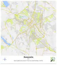
An updated version was printed in 2012 in Russian and using a custom mapnik style.
Sources available here: http://www.jekader.net/osm/paper_map_2012/
Collada 3D buildings
Generate 3D buildings in collada format embedded in kml. Collada 3D Building
People involved
- Golovco Anatolie
- Puscasu Ion
- Budac Andrei
- Moldovan_Merkator
- Covas Igor
- Ruslan Pislaru
- Veaceslav Filimon
- jekader
- Leah Viorica
- Iacovlev Pavel
- Teddy Bear
- Wowek(R)
- Leolik
Discussions
Google Groups: OSM Moldova
Telegram Messenger: OSM Moldova
Notes and references
- 1 2 not to be confused with the Pridnestrovian Moldavian Republic on Wikipedia (Republica Moldovenească Nistreană)!