Tag:aerialway=station
 |
| Description |
|---|
| A station where passengers and/or goods can enter and/or leave the aerialway |
| Rendering in OSM Carto |
 |
| Group: Aerialways |
| Used on these elements |
| Useful combination |
|
| Status: de facto |
| Tools for this tag |
|
A station where passengers can enter and/or leave the aerialway (ski lift or cable car) or where goods can be loaded and unloaded.
How to map
Place a node ![]() at the location of the station, and add the tag aerialway=station. The nodes should also be the ends of the way representing a lift (so a way that has the aerialway=gondola tag or similar).
at the location of the station, and add the tag aerialway=station. The nodes should also be the ends of the way representing a lift (so a way that has the aerialway=gondola tag or similar).
Or you can draw the building, and add the tag aerialway=station. In this case, the aerialway ends at the building.
Additionally you might want to add:
| Tag | Description | Picture |
|---|---|---|
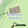
| aerialway:station=bottom | station at the end of the aerialway with the lower altitude | 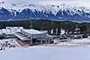 |
| aerialway:station=top | station at the end of the aerialway with the higher altitude | |
| aerialway:station=mid | any station not being at the end of and aerialway |  |
Tags to use in combination
- name=*
- operator=*
- ele=*
- aerialway:access=entry/exit/both/no
- opening_hours=*
Rendering
Photos
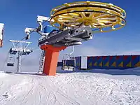
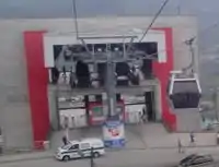 Gondolas disappearing into a station building
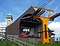
| ||||||||||||||||||||||||||||||||||||||||||||||
This article is issued from Openstreetmap. The text is licensed under Creative Commons - Attribution - Sharealike. Additional terms may apply for the media files.