Tag:water=dock
 |
| Description |
|---|
| An enclosed area of water for ships and other craft within which the height of the water can be managed. |
| Rendering in OSM Carto |
 |
| Group: Natural |
| Used on these elements |
| Useful combination |
| See also |
| Status: in use |
| Tools for this tag |
|
The water=dock tag is used to identify an enclosed area of water for ships and other craft within which the height of the water can be managed.
How to Map
Draw an ![]() area and tag it with natural=water, water=dock. Optionally also add a name=*, operator=*, wikipedia=* etc. In addition the dock tag can be used to indicate the type of dock:
area and tag it with natural=water, water=dock. Optionally also add a name=*, operator=*, wikipedia=* etc. In addition the dock tag can be used to indicate the type of dock:
- dock=tidal - For a tidal dock, where the dock holds a stable water level in a basin, in order to make loading and offloading of ships easier, or to have a safe harbour in areas with a large tidal difference.
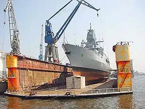
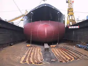
- dock=drydock - Usually a maintenance dock where ships can enter to do inspections and maintenance on the wet surface of the hull.
- dock=floating - Floating docks are usually a large floating structure with the purpose to lift a vessel out of the water for maintenance or inspections of the wet surface of the hull.
Note that "floating dock" may be used to refer to both an impounded tidal dock and a floating structure. See the relevant Wikipedia entries below for clarification.
Example
Dry Dock in Singapore
Barrow-in-Furness has two docks.
See also
- Harbour
- Dock (maritime) on Wikipedia
- Floating dock (impounded) on Wikipedia
- Floating dock (jetty) on Wikipedia
- man_made=pier
- man_made=quay
This article is issued from Openstreetmap. The text is licensed under Creative Commons - Attribution - Sharealike. Additional terms may apply for the media files.