WikiProject Belgium/Sonian Forest
Forêt de Soignes / Zoniënwoud / Sonian Forest
Cycling
Cycling routes
Cycling nodes
- 43
- 44
- 46
- 60
Walking routes
 GR126
GR126- GR512
- GR579
- GR126 - GR579
- Promenade Verte / Groene Wandeling
- Balades / Wandelingen
- 1
 Balade de la Forêt de Soignes bruxelloise / Wandeling in het Brusselse deel van het Zoniënwoud (23 km)
 - 2 Sentier éducatif Rouge-Cloître / Leerwandelpad Rood Klooster (4 km)
- 4 Sentier éducatif des Enfants Noyés / Leerwandelpad Verdronken Kinderen (3.4 km, Blue sign)
- 5 Promenade Ruusbroec / Ruusbroecwandeling (5.4 km, Orange post )
- 6 Promenade du Chêne De Bruyn (Schone-Eik) / De Schone-Eikwandeling (8.5 km, Red sign)
- 7 Promenade de l'Espinette centrale (Middenhut) / Middenhutwandeling (9 km, Blue post)
- 8 Promenade du Hazendal / Hazendalwandeling (3.5 km, Red post )
- 9 Promenade du Flossendelle / Flossendellewandeling (6 km, Blue post)
- 10 Promenade de la Warande / Warandewandeling (5.6 km, Blue post)
- 11 Promenade du Kapbos de Duisburg / Kapboswandeling Duisburg (9 km, Yellow post)
- 12 Sentier didactique au parc Tournay-Solvay / Leerpad van het Tournay-Solvay-park (2 km)
- 1
Running routes
Parts
Brussels Capital Region
38% of the forest is in Brussels Capital Region.
 Gate for cars
barrier=gate Blocking horseback riders
barrier=? Cycle barrier
barrier=cycle_barrier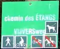 Sign with restrictions
 Horseback riders only
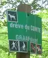 Only cycle and foot, dog on leash
 No restriction, dog on leash
 Foot only
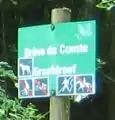 Foot only, dog on leash
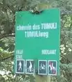 No horse.
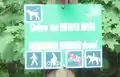 No motorcycle, dog on leash
Vlaams Brabant
56% of the forest is in Flemish Brabant.
Brabant wallon
6% of the forest is in Walloon Brabant.
Forêt de Soignes / Zoniënwoud highways tagging guidelines (draft)
(Following the discussions on the talk-be mailing list, here is a draft.)
010 is the highway physically designed for motor cars, forestry trucks, etc.? yes, goto 100 | no, goto 015
015 is it designated for horses? yes, goto 140 | no, goto 020
020 is it designated for bicycle? yes, goto 165 | no, goto 200
100 tag highway=track (e.g. drève, etc., with access for forestry trucks)
105 tag surface=asphalt or surface=concrete or surface=gravel or surface=ground, etc. (e.g. Drève des Tumuli : asphalt)
110 precise restrictions e.g. motorcar=no or bicycle=yes, etc.
115 if appliable, tag oneway=yes or oneway=no
120 if appliable, tag noexit=yes or noexit=no
145 tag surface=* with paved | unpaved | asphalt | concrete | cobblestone | gravel | sand
170 tag surface=* with paved | unpaved | asphalt | concrete | cobblestone | gravel
205 tag surface=* with paved | unpaved | asphalt | concrete | cobblestone | compacted | gravel
210 tag bicycle=yes or bicycle=no or bicycle=designated
215 tag horse=yes or horse=no or horse=designated
220 tag foot=yes or foot=no or foot=designated
225 tag motorcycle=yes or motorcycle=no
230 tag access=*
Notes:
- See also: http://wiki.openstreetmap.org/wiki/Hiking).
- Refer to the tagging scheme of the Forêt de Fontainebleau, France.
- (path and not footway; IMHO footway is for urban areas; see: Footway: For designated footpaths, i.e. mainly/exclusively for pedestrians.)
Foxandpotatoes 17:22, 26 February 2010 (UTC)