The book Finding Your Way Without Map or Compass by Harold Gatty (Goodreads review) is well worth a read if you're interested in this sort of thing. The chapters Reflections in the Sky and Directions from the Wind are particularly relevant
It includes more accurate ways of solar navigation, tips about moss on trees, and many others.
Wind
If you know the dominant* wind direction in open country, isolated trees will lean away from it. This is obvious on Dartmoor (an upland area in Southern England I know well) for example. This works less well in valleys that affect the local wind direction. In mid-latitudes the prevailing wind is usually broadly from the west, but SW is a better estimate round here.
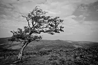
Lone Tree near Combestone Tor, Dartmoor, England. Jeffrey Pardoen, cc-by-2.0 via Wikimedia Commons
Again, using the prevailing wind, airport runways are often aligned to it - but paved ones have their direction painted on them anyway; even grass strips are likely to have some indication if they have any infrastructure at all.
Orientation to the sun
Old factory buildings (predating cheap electric lighting), where they survive, often have northlights forming a saw-tooth roof (Wikipedia) - the (near-)vertical panes face away from the equator.
A more modern variation on that is solar panels - they will face towards the sun. If sited freely on the ground, they will face S in the northern hemisphere. Rooftop panels will usually face more S than N (again in the northern hemisphere) but are constrained by the roof angle.
Returning to trees, many species show greater growth on the sunward side, with longer, flatter, branches
If you have a map, even a basic or mental one, but no compass
This is becoming less common as mapping is increasingly electronic, but with a map but no compass, there are things you can do.
In the dark, the lights of towns reflect off the clouds, giving you the direction towards them even if they're the other side of a hill. Or in Gatty's words:
On land an overcast sky can signal signal many different things to the traveler. One of the simplest and most important of these things is the well-lit human city, town, airfield beacon, or even powerful lighthouse. The loom of these lights in the sky can often be seen when their source is below the observer's horizon.
Near the coast, you can often tell which way the sea is even if you can't see it. Gatty goes into more detail, but if in one direction there are clearly no hills behind the closest few, that will mean the sea (or a plain). Sea birds can help here too.
Of course if you know where you are, and there's a distinctive peak or similar feature on the map and visible, you can orient the map to that. In that case even a mental map and knowledge of the area can help. I know there's a radio mast called Mendip, as the eastern end of those hills. That's enough to get my bearings if it's within sight, combined with knowing the terrain I'm in (if it's not hidden by cloud of course). On Dartmoor I can recognise some of the hills, and know roughly how they relate to each other. There I'd have a paper map, so even if my phone battery died and I lost my compass, that would be enough for navigation if the cloudbase was above the hills.
---
* I originally wrote "prevailing wind", but on re-reading Gatty this weekend I realised that was a slight error or inconsistency : he defines the dominant wind in a way that takes into account the strength as well as the frequency for a direction - a weighted average, while the prevailing wind only considers the frequency. In many areas they will be similar enough to make no difference for our purposes.
