Tag:aeroway=navigationaid
 |
| Description |
|---|
| A facility that supports visual navigation for aircraft |
| Group: Aeroways |
| Used on these elements |
| Useful combination |
| See also |
| Status: de facto |
| Tools for this tag |
|
Air navigation aid stations support the different visual systems that help pilots guide their aircraft during flight.
How to map
Place a node ![]() at the location of the navigation aid, and tag with aeroway=navigationaid.
at the location of the navigation aid, and tag with aeroway=navigationaid.
Tags to use in combination
- navigationaid=* - specifying the type of navigation
- navigationaid=als -
 Approach lighting system
 - navigationaid=papi - Precision approach path indicator
- navigationaid=vasi - Visual Approach Slope Indicator
- navigationaid=txe - Taxiway-Edge (blue)
- navigationaid=txc - Beaconing taxiway centreline (green)
- navigationaid=als -
Example
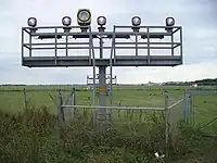
- The approach lighting system of Bremen airport
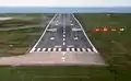 The PAPI can be seen to the right of the runway. The plane is below the glideslope.
See also
- airmark=beacon - radio navigation aid system
- man_made=beacon - often used as a complementary tag to this tag
- man_made=lighthouse - for tower used to display marine navigation light
- man_made=compass_rose
Possible tagging mistakes
This article is issued from Openstreetmap. The text is licensed under Creative Commons - Attribution - Sharealike. Additional terms may apply for the media files.