Tag:tunnel=culvert
 |
| Description |
|---|
| For a stream/drain/ditch passing under a road. Use it on the section of waterway passing under the road. |
| Rendering in OSM Carto |
 |
| Group: Waterways |
| Used on these elements |
| Useful combination |
| Status: de facto |
| Tools for this tag |
|
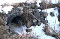
A culvert is a device used to channel water. It may be used to allow water to pass underneath a road, railway, or embankment for example. Culverts can be made of many different materials; steel, polyvinyl chloride (PVC) and concrete are the most common. Formerly, construction of stone culverts was common.
Typical culvert is a pipe buried under the road. Very large culverts may be hard to distinguish from bridges. Culverts commonly carry waterway=stream, waterway=drain, and waterway=ditch, but there are also large culverts carrying waterway=river.
tunnel=flooded may be used to map larger and longer tunnels used to channelise any fluid.

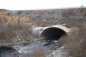 Culvert large enough to contain river rather than drain or stream
How to map
Tag the section of covered waterway, including layer=* as usual for tunnels.
culvert=inverted_siphon may be added for sections of a waterway diving under another waterway.
See tunnel=* for a description of the preferred way of connecting culvert waterways to adjoining waterway sections.
Possible tagging mistakes
See also
- Culvert on Wikipedia
- Water feature#Navigations
- Different types of culverts (Cornell University) [ dead link ]
- The discussion page for details of an earlier OSM tagging system, culvert=yes.