Tag:aerialway=goods
 |
| Description |
|---|
| A cable supported lift for conveying goods, not passengers. Consider other values for aerialway in combination with access and usage keys instead of this. |
| Rendering in OSM Carto |
 |
| Group: Aerialways |
| Used on these elements |
| Useful combination |
| Status: in use |
| Tools for this tag |
|
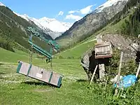
A cable/wire supported lift for conveying goods. Passenger transport is usually not allowed. To specify a certain good transported you may use cargo=*.
Consider using detailed aerialway=* type with a combination of foot=no and/or usage=freight and/or usage=industrial instead of this tagging.
This is an unusual classification among several cable/wire based lifts/transportation types listed under aerialway=*. See also WikiProject Piste Maps.
How to map
Draw a way ![]() along the route of the cable, and set this aerialway=goods tag on this way.
along the route of the cable, and set this aerialway=goods tag on this way.
Additional features
Position nodes ![]() at either end of the cable. These nodes might be tagged with aerialway=station
at either end of the cable. These nodes might be tagged with aerialway=station
If you know the position you can also map support pylons by positioning nodes ![]() in the middle of the way, with the tag aerialway=pylon.
in the middle of the way, with the tag aerialway=pylon.